
| Home Page | |
| FAQ | |
| Publications | |
| Documentation | |
| Software | |
| Movies | |
| Image Gallery | |
| Image Data | |
| Validation | |
| Data Search | |
| Derived Products | |
| Related Links | |
| Contact Us | |
| SCP file site | |
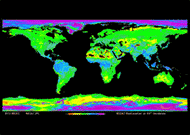
The NASA Scatterometer Climate Record Pathfinder (SCP) is a NASA sponsored project to develop scatterometer-based data time series to support climate studies of the Earth's cryosphere and biosphere. Originally developed to measure winds over the ocean from space, scatterometer data has proved to be very useful in a variety of studies including polar ice and tropical vegetation. Because the scatterometer radar signal can penetrate the surface, a scatterometer can observe subsurface/subcanopy climate-related features. The launch of Seasat, carrying a Ku-band scatterometer
(SASS), in 1978 provided a baseline against which
studies of global change can be measured. Other
missions have followed SASS, including the C-band
European Space Agency (ESA) Earth Remote Sensing (ERS)
-1 and -2 missions (1992-2001), the NASA Scatterometer
(NSCAT) mission in 1996-97, SeaWinds on QuikSCAT The SCP datasets are based on a time series of enhanced resolution images made from the scatterometer backscatter (sigma0) measurements using the Scatterometer Image Reconstruction (SIR) and SIR w/filtering algorithms. For the highest possible spatial resolution (as well as to ensure full coverage over the images) multiple orbit passes are combined. For SASS, NSCAT, ERS, and ASCAT images of sigma0 at 40 deg incidence angle (A) in dB and the slope of sigma0 versus incidence angle (B) in dB/deg are made. For SeaWinds and QuikSCAT sigma0 images at the observation incidence angle are made. In addition to these images, a number of ancillary images and products are generated include sea ice extent maps and sea ice motion data sets. A number of derived products are provided. SCP images and data products are designed to support climate studies over land and ice. Scatterometer data sets are augmented by processed image data from the TRMM Precipitation Radar (TRMM-PR), SSM/I, and AMSR-E microwave radiometers. Products can be selected from Image Data on the navigation bar to the left. A brief summary of available products is given here. Scatterometer Instrument Comparison Obtaining Data Binary-formatted data is available by https under the "Image Data" link to the left. Most users will be interested in A-type .sir files. Software readers for the files are available under the "Software" link. The web site is organized to facilitate scripted data downloads. Using our data? Send an email to long@ee.byu.edu letting us know what you're doing. This will help ensure that we have the funding needed to keep operating. Recent News Updates Feb 2024. Our webserver suffered some major failures at the end of December, it is currently unstable and is up and down. We are behind in processing ASCAT-a and ASCAT-b images, but they should appear on the site soon. Jun 2021. NOTE: Starting in July, the SCP ftp site will be shutdown. Thereafter all data must be obtained using https. The URL will be the same with "ftp:" replaced by "https:". Jan 2021. The consolidated Antarctic Tabular Iceberg Database has been updated and is available for download. Jan 2021. A special page on tracking iceberg A68a that includes animations and information on relatieve iceberg sizes was kept up to date active from Dec 2020 through Mar 2021 Iceberg A68a. Jan 2020. The SCP has collaborated with NSIDC to produce the "MEaSUREs Calibrated Enhanced-Resolution Calibrated Passive Microwave Daily EASE-Grid 2.0 Brightness Temperature (CETB) Earth System Data Record (ESDR)". This data set spans 1978-2019 with intercalibrated brightness temperature measurements from AMSR-E, SMMR, SSM/I, and SSMIS all on compatible grids. This data set superceeds the SCP's own brightness temperature image products. |
 (1999-2000),
SeaWinds on ADEOS-II/Midori2 (2003), multiple ESA Advanced
scatterometer (ASCAT) (2009+), and the Indian OSCAT scatteromaters.
With their rapid
global coverage, day or night and all-weather
operation, scatterometers offer a unique tool for
long-term climate studies. The goal of the SCP is to
provide scatterometer-based datasets to researchers
involved in climate studies.
(1999-2000),
SeaWinds on ADEOS-II/Midori2 (2003), multiple ESA Advanced
scatterometer (ASCAT) (2009+), and the Indian OSCAT scatteromaters.
With their rapid
global coverage, day or night and all-weather
operation, scatterometers offer a unique tool for
long-term climate studies. The goal of the SCP is to
provide scatterometer-based datasets to researchers
involved in climate studies.