
| News | |
| QuikScat | |
| NSCAT | |
| YSCAT | |
| SAR Research | |
| SCP | |
| CERS | |
| Jason-1 | |
| Publications | |
| Software | |
| Studies | |
| Lab Resources | |
| Group Members | |
| Related Links | |
| Contact Us | |
| Getting to BYU | |

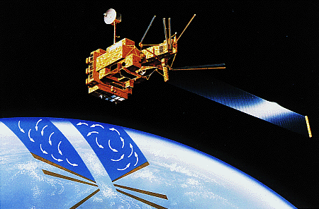 NSCAT picture (59K)

NSCAT Antarctic Ice Masked Animated Gif -Small(885KB) Animated Gif -Large (5.449 MB) AVI movie (4.434 MB) Mpeg movie (2.137 MB) QuickTime (1.594 MB) |
NSCAT Arctic Ice Masked Animated Gif (8.192 MB) AVI movie (4.209 MB) Mpeg movie (1.14 MB) QuickTime (990 KB) |
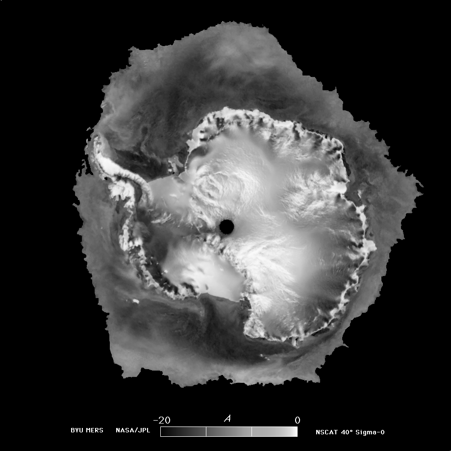
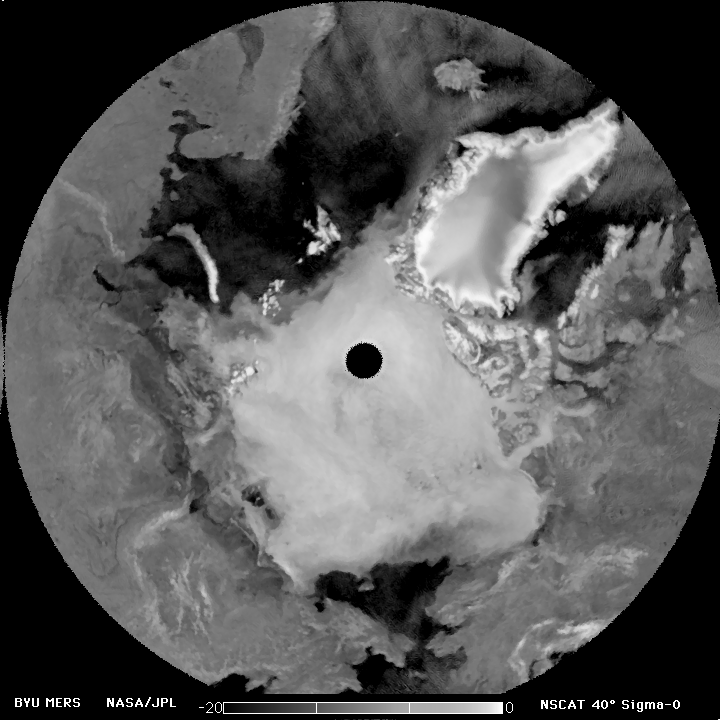
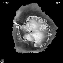
A full global image as produced from NSCAT data is shown in Figure 3 (b/w gif 402K) (color gif 383K) . The brightest regions are glacial ice sheets in Greenland and Antarctica as described above. For other regions, the brightness of the image is related to the vegetation cover and soil moisture. Tropical rainforests along the equator in South America, Africa, and Southeast Asia are relatively bright while desert regions are dark. Very dry, sandy deserts show up as black in this image. Some examples are the Empty Quarter in Saudia Arbia, the Gobi desert in Western China, and the great erg (sand dune) seas in Sahara desert in North Africa. The light area just below the wide, dark band in Africa is known as the Sahel. This area lightens and darkens with the changing season and drought conditions in Africa. The seasonal radar response of the Sahel is thought to be a sensitive indicator of desertification due to global warming and climate change.
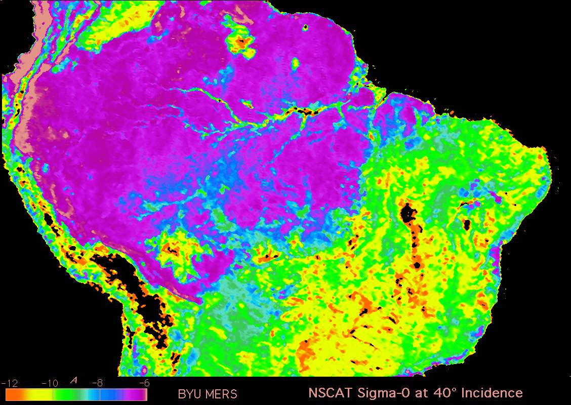
Tropical rainforests are critical to the climate health of the world and are thought to contain 1/2 of all the world's species. Figure 4 [hires b/w gif 523K] [lores b/w gif 99K] [color gif 492K) shows the Amazon rainforest over South America as observed by NSCAT. Because the radar response is sensitive to the type and density of vegetation, the scatterometer data can provide information useful for discriminating and mapping vegetation. A false color image helps discriminate general areas of tropical rainforest (blues and purples) from woodlands and savannah (greens and yellows). Mountains and degraded farm lands show up as black. [Note: data is not calibrated so this IS NOT a classified image.] The NSCAT data is able to delineate the extent of the tropical rainforest. Comparison of this image taken in 1996 with images made from Seasat scatterometer data collected in 1978 may help reveal the extent of tropical deforestation in this sensitive area.
![[hires b/w gif 523K]](images/NSCAT/NSCAT_415-631_cal4.gif)
![[lores b/w gif 99K]](images/NSCAT/NSCAT_amazon_lowres.gif)
Statistical Modeling
We have been developing improved statistical models for the scatterometer measurement process. Some of the areas studied include:- Sensor calibration
- Signal processing design and performance
- Probability distribution of NSCAT sigma-0 measurements
- Geophysical modeling uncertainty
- Cramer-Rao accuracy bound for wind estimation
- Improved wind retrieval techniques
- Ambiguity removal algorithm and accuracy assessment techniques
- Distribution of negative NSCAT sigma-0 measurements.
- Automated sea ice extent mapping
- Azimuth modulation of backscatter in Antarctica
- Sea ice classification
NSCAT NASA Press Releases
Selected NSCAT Related Papers
- Q.P. Remund and D.G. Long, "Large-scale Inverse Ku-band Backscatter Modeling of Sea Ice," IEEE Transactions on Geoscience and Remote Sensing, Vol. 41, No. 8, pp. 1821-1832, doi:10.1109/TGRS.2003.813495, 2003.
- D.G. Long and M.R. Drinkwater, "Azimuth Variation in Microwave Scatterometer and Radiometer Data Over Antarctica," IEEE Transactions on Geoscience and Remote Sensing, Vol. 38, No. 4, pp. 1857-1870, do:10.1109/36.851769, 2000.
- J. Zec, W.L. Jones, and D.G. Long, "NSCAT Normalized Radar Backscattering Coefficient Biases Using Homogenous Land Targets," Journal of Geophysical Research, Vol. 104, No. C5, pp. 11557-11568, doi:10.1029/1998JC900098, 1999.
- W-Y Tsai, J.E. Graf, C. Winn, J.N. Huddleston, S. Dunbar, M.H. Freilich, F.J. Wentz, D.G. Long, and W.L. Jones, "Postlaunch Sensor Verification and Calibration of the NASA Scatterometer," IEEE Transactions on Geoscience and Remote Sensing, Vol. 37, No. 3, pp. 1517-1542, doi:10.1109/36.763264, 1999.
- T. Oliphant and D.G. Long, "Accuracy of Scatterometer-Derived Winds Using the Cramer-Rao Bound," IEEE Transactions on Geoscience and Remote Sensing, Vol. 37, No. 6, pp. 2642-2652, doi:10.1109/36.803412, 1999.
- D.G. Long and M.R. Drinkwater, "Cryosphere Applications of NSCAT Data," invited paper, IEEE Transactions on Geoscience and Remote Sensing, Vol. 37, No. 3, pp 1671-1684, doi:10.1109/36.763287, 1999.
- Q.P. Remund and D.G. Long, "Sea Ice Extent Mapping Using Ku band Scatterometer Data," Journal of Geophysical Research, Vol. 104, No. C5, pp. 11515-11527, doi:10.1029/98JC02373, 1999.
- A.E. Gonzales and D.G. Long, "An Assessment of NSCAT Ambiguity Removal," Journal of Geophysical Research, Vol. 104, No. C5, pp. 1149-11457, doi:10.1029/98JC01943, 1999.
- P.E. Johnson and D.G. Long, "The Probability Density of Spectral Estimates Based on Modified Periodogram Averages," IEEE Transactions on Signal Processing, Vol. 47, No. 5, pp 1255-1261, doi:10.1109/78.757213, 1999.
- J. Graf, C. Sasaki, C. Winn, W.T. Liu, W. Tsai, M. Freilich and D.G. Long, "NASA Scatterometer Experiment," Acta Astronautica, Vol. 43, No. 7-8, pp. 377-407, doi:10.1016/S0094-5765(97)00180-X, 1998.
- D.G. Long, "Comparison of TRMM and NSCAT Observations of Surface Backscatter Over the Amazon Rainforest," Proceedings of the International Geoscience and Remote Sensing Symposium, pp. 1879-1881, Seattle, Washington, doi:10.1109/IGARSS.1998.703682, 6-10 July, 1998.
- F. Naderi, M. H. Freilich, and D. G. Long, "Spaceborne Radar Measurement of Wind Velocity Over the Ocean--An Overview of the NSCAT Scatterometer System", invited paper, Proceedings of the IEEE, pp. 850-866, Vol. 79, No. 6, doi:10.1109/5.90163, June 1991.
- D. G. Long and J. M. Mendel, "Identifiability in Wind Estimation from Wind Scatterometer Measurements," IEEE Transactions on Geoscience and Remote Sensing, Vol. 29, No. 2, pp. 268-276, doi:10.1109/36.73668, 1991.
- S. J. Shaffer, R.S. Dunbar, S. V. Hsiao, and D.G. Long, "A Median-Filter-Based Ambiguity Removal Algorithm for NSCAT," IEEE Transactions on Geoscience and Remote Sensing, Vol. 29, No. 1, pp. 167-174, doi:10.1109/36.103307, Jan. 1991.
- D. G. Long, C-Y Chi, and F. K. Li, "The Design of an Onboard Digital Doppler Processor for a Spaceborne Scatterometer," IEEE Transactions on Geoscience and Remote Sensing, Vol. 26, No. 6, pp. 869-878, doi:10.1109/36.7718, Nov. 1988.
- C-Y Chi, D. G. Long and F. K. Li, "Radar Backscatter Measurement Accuracies Using Digital Doppler Processors in Spaceborne Scatterometers," IEEE Transactions on Geoscience and Remote Sensing, Vol. GE-24, No. 3, pp. 426-437, doi:10.1109/TGRS.1986.289602, May 1986.