 |
|
 |
PUBLIC INFORMATION OFFICE
JET PROPULSION LABORATORY
CALIFORNIA INSTITUTE OF TECHNOLOGY
NATIONAL AERONAUTICS AND SPACE ADMINISTRATION
PASADENA, CALIF. 91109. TELEPHONE (818) 354-5011
https://www.jpl.nasa.gov
Contact: Mary A. Hardin
 at AGU Newsroom (415)
905-1107 at AGU Newsroom (415)
905-1107
FOR IMMEDIATE RELEASEDecember
8, 1997
SEASAT, NSCAT DETECT CHANGES IN GREENLAND ICE SHEET
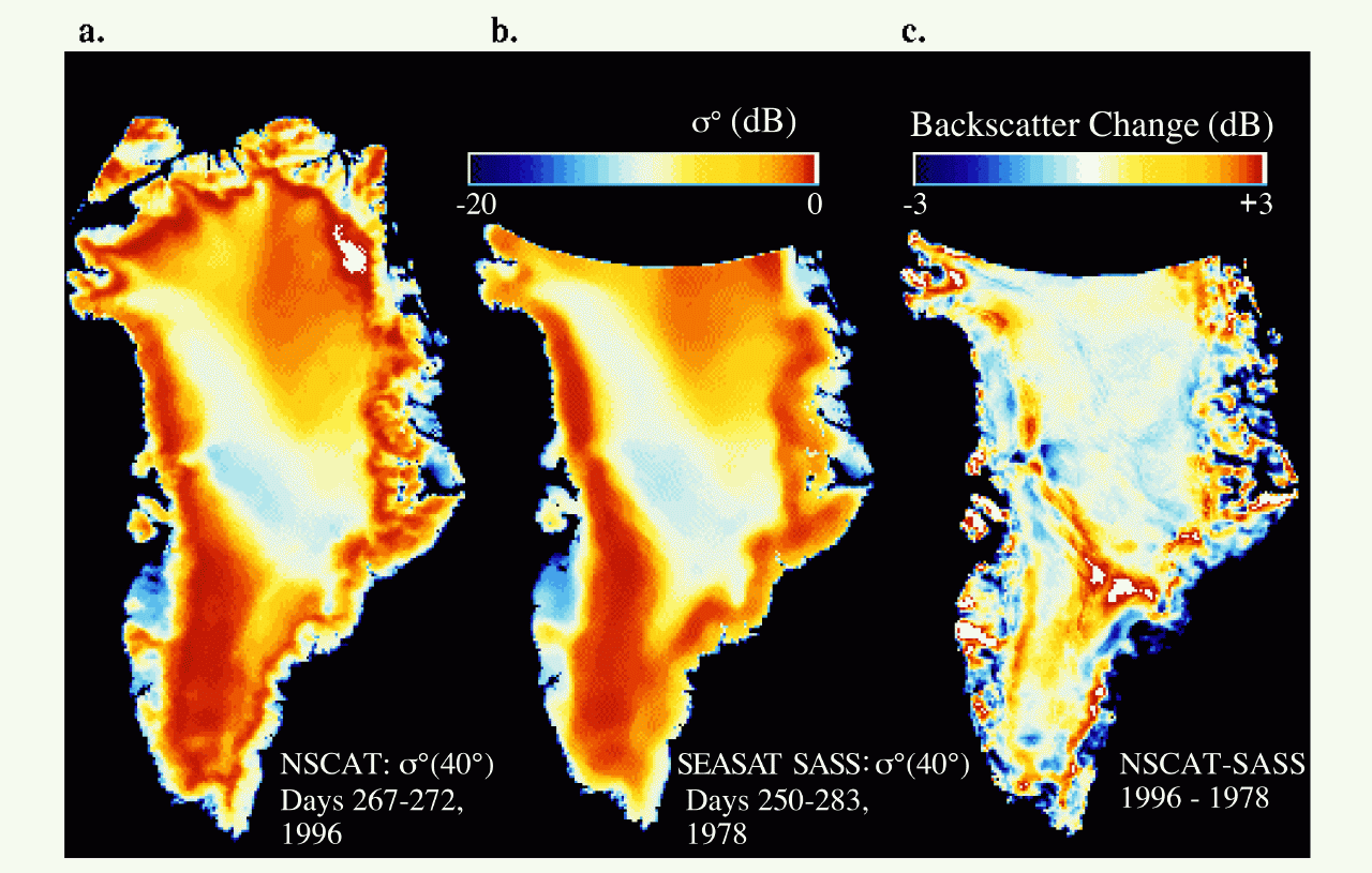
Scientists comparing
data collected by the Seasat Scatterometer (SASS) with images acquired
by the NASA Scatterometer (NSCAT) have detected significant changes
in the characteristics and extent of dry snow cover at Greenland's
highest elevations during the 18-year gap between both missions.
Dr. Mark Drinkwater
of NASA's Jet Propulsion Laboratory, Pasadena, CA, and co-author Dr.
David Long of Bringham Young University, Provo, Utah, will be presenting
their findings this week at the annual fall meeting of the American
Geophysical Union in San Francisco, CA. The special session on Greenland
will be held on Monday, Dec. 8, at 10:30 a.m. Pacific Standard Time.
"The area impacted by
recent summer melting on Greenland is significantly larger than that
previously observed. It appears that climate changes over the last
two decades have influenced patterns of snow accumulation and melting
on Greenland. A persistent increase in the melting of the ice sheet
would ultimately affect sea levels," Drinkwater said. "The extent
of the polar ice sheets helps preserve the global energy balance as
the ice sheets reflect incoming solar energy and, thus, help regulate
Earth's temperature."
NASA's Seasat mission
was launched in 1978 and carried five instruments to measure wind
speed and direction, sea-surface temperature, the amount of water
in the atmosphere, ocean waves and the polar ice fields. Seasat operated
for 100 days before an electrical short circuit ended the mission.
The NASA Scatterometer
(NSCAT), designed to study wind speed and direction over the oceans,
was launched in August 1996 on Japan's Advanced Earth Observing Satellite
(ADEOS). However, the satellite suffered a fatal solar array problem
that prematurely ended the mission on June 30, 1997.
Despite the short lifetimes
of both missions, the scatterometers have provided scientists with
valuable information about winds over the ocean. Data from the missions
have also been used to study changes in the polar ice sheets.
"Although originally
designed to measure ocean winds, spaceborne microwave radar scatterometers
such as NSCAT can be used effectively to study changes in large polar
ice sheets. Our results show a clear reduction in the location and
extent of the dry-snow zone as a result of increased melting since
1978. The largest changes occur at the boundary of the dry snow zone
in the southwestern part of the ice sheet. The dry-snow zone is the
high altitude portion of the Greenland ice cap, which normally experiences
no summer melting," Drinkwater said. "These changes are consistent
with a 10-year warming trend and an increase of more than 1 degree
C (1.8 degrees F) between 1979 and the present day, except for the
summer of 1992, when ash from the Mt. Pinatubo eruption may have temporarily
helped to cool the northern hemisphere."
Scientists need a long-term,
consistent measurement record to help them determine the extent of
melting and the impact of climate change upon the Greenland and Antarctic
ice sheets. NASA has approved the Quick Scatterometer mission (QuikSCAT)
to fill in the measurement gap caused by the loss of NSCAT. These
data will help scientists continue to monitor the changes on Greenland
and around the globe.
The NSCAT and Seasat
images are available on JPL's web site at https://www.jpl.nasa.gov/news.
JPL, a division of the
California Institute of Technology, managed the Seasat and NSCAT missions
for NASA's Office of Mission to Planet Earth, Washington, DC.
#####
11/26/97 MAH
#97114
|
|

