| The wide swath and frequent overflights permit generation of a wide variety
of SeaWinds Image products. For highest possible spatial resolution, multiple
orbit passes are combined. These are the 'all pass' images. Since generally
orbit passes of a given point on the Earth occur at nearly the same time
of day, time-of-day studies are facilitated by computing images from ascending
(morning) passes only, and descending (evening) passes only.
For improved temporal resolution in the polar regions, daily
local-time-of-day images have been generated.
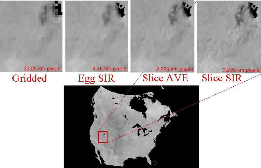
Images are made both from the SeaWinds on QuikScat "egg" backscatter
measurements and from the "slice" measurements. Generally, slice measurements
yield higher spatial resolution but are noiser than egg measurements.
Further information is available in the QuikSCAT
Enhanced Resolution Image Users Notes.
Note that these enhanced resolution sigma-0 images are different than the
QuikSCAT Sigma-0 Browse Product images,
which are non-enhanced resolution image products designed for rapid browings.
NOTE: This page ONLY accesses images processed from the
VERSION 1 QuikSCAT L1B files.
JPL switched to VERSION 2 processing in mid 2006 (JD 189). Due to
differences in the processing, the slice location, incidence angles,
and calibration, the VERSION 1 files are slightly different than
the VERSION 2 L1B files. JPL is reprocesing the entire mission
to VERSION 2. To avoid continuity problems between the
two versions, the sigma-0 images are kept separate.
Images processed from new VERSION 2 data (all data after JD 189, 2006) can
be found in the data/qscatv2 directory on the ftp site or accessed here.
Eventually, as our available processing
power permits, we will reprocess the entire QuikSCAT data set so that a
complete set of VERSION 2 images are available.
We plan to keep both versions, at least for a while, but may eventually
phase out images processed VERSION 1 data.
The file format naming scheme, etc. for SCP images made from VERSION 1 and VERSION 2 QuikSCAT files are identical and all utilities, land masks, etc. work the same on both versions.
|
Available Version 1 (99-06)
Image Classes
(Use Version 2 for 06+)
* Only Ant, Arc, and Grn regions
** Only Ant region
*** Only Arc and Grn regions
|