SeaWinds on QuikScat Enhanced Resolution Image Products (version 2)
| The wide swath and frequent overflights permit generation of a wide variety
of SeaWinds Image products. For highest possible spatial resolution, multiple
orbit passes are combined. These are the 'all pass' images. Since generally
orbit passes of a given point on the Earth occur at nearly the same time
of day, time-of-day studies are facilitated by computing images from ascending
(morning) passes only, and descending (evening) passes only.
For improved temporal resolution in the polar regions, daily
local-time-of-day images have been generated.
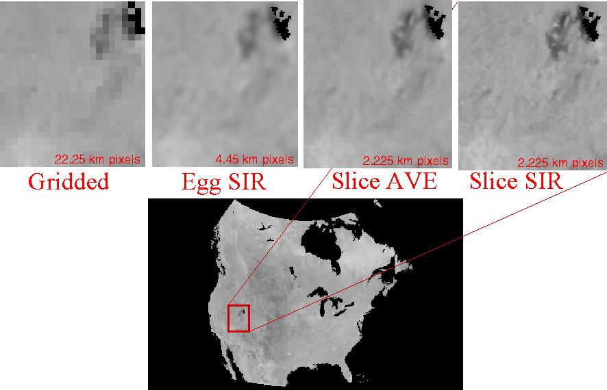
Images are made both from the SeaWinds on QuikScat "egg" backscatter
measurements and from the "slice" measurements. Generally, slice measurements
yield higher spatial resolution but are noiser than egg measurements.
The nominal image pixel resolution for egg images is 4.45 km/pixel while the nominal image pixel resolution for slice images is 2.225 km/pixel.
Further information is available in the QuikSCAT
Enhanced Resolution Image Users Notes.
Note that these non-enhanced and enhanced spatial resolution sigma-0 images are different than the
QuikSCAT Sigma-0 Browse Product images,
which are designed only for rapid browsing. (note:large page loads slowly)
|
Available Image Classes
* Only Ant, Arc, and Grn regions
** Only Ant region
*** Only Arc and Grn regions
+ sea ice masks are in quev and qusv, Ant and Arc
++ non-polar regions only
|
Images are produced in the BYU .SIR file
format using the standard naming scheme.
The files are gzipped to minimize storage and transfer requirements. The
standard images are designed for land and ice observation. Data over the
ocean is generally not useful. However the distributed images are not land
masked. .SIR format land mask files (containing 0 for ocean and 1 for land)
are available for each standard region. .SIR format images containing "images"
of the latitude and longitude of each pixel for each region are also available.
Enhanced resolution image formation algorithm described in
D.S. Early and D.G. Long, "Image Reconstruction and Enhanced Resolution Imaging from Irregular Samples," IEEE Transactions on Geoscience and Remote Sensing, Vol. 39, No. 2, pp. 291-302, 2001.
Sea ice extent and sea ice edge derived as described in Q.D. Remund and D.G. Long, "A Decade of QuikSCAT Scatterometer Sea Ice Extent Data", IEEE Transactions on Geoscience and Remote Sensing, doi:10.1109/TGRS.2013.2281056, Vol. 52. No. 7, pp. 4281-4290, 2014.
|
Resolution Comparison
 |
NOTE: This page provides access to images processed from
the Version 2 QuikSCAT L1B files. JPL switched to
Version 2 processing in mid 2006 (JD 189). Due to differences in the
processing, the slice location, incidence angles, and calibration, the
Version 1 files are slightly different than the Version 2 L1B files.
JPL has reprocessed the entire QuikSCAT mission dataset to Version 2
and we have followed suit. Selected mages processed from the old Version 1
data (only for data prior to JD 189, 2006) can be found in the data/qscatv1
directory on the ftp site. This data will eventually be deleted.
The file format naming scheme, etc. for SCP images made from
Version 1 and Version 2 QuikSCAT files are identical and all
utilities, land masks, etc. work the same on both versions. Note,
however, that ascending and descending polar images have been
discontinued in Version 2, replaced with local time of day
images.
|
