
| News | |
| QuikScat | |
| NSCAT | |
| YSCAT | |
| SAR Research | |
| SCP | |
| CERS | |
| Publications | |
| Software | |
| Studies | |
| Lab Resources | |
| Group Members | |
| Related Links | |
| Contact Us | |
| Getting to BYU | |
The Winds and Currents MissionThe proposed Winds and Current Mission (WaCM) is designed to collect data on ocean winds and currents simultaneously through satellite observance. While QuikSCAT and ASCAT had the ability to collect wind data, they could not sufficiently sample surface currents. Current measurement requires a new system be built. Because the winds and currents in oceans affect ocean circulation, fluxes, transportation of heat, nutrients, and gases, and atmospheric forcing, WaCM will improve understanding of the following:
WACM will be able to measure the surface wind velocities, the current velocities, the curl of the wind stress (which is error prone), and the curl of the surface currents (which is error prone). In order to do this, the satellite has the following requirements:
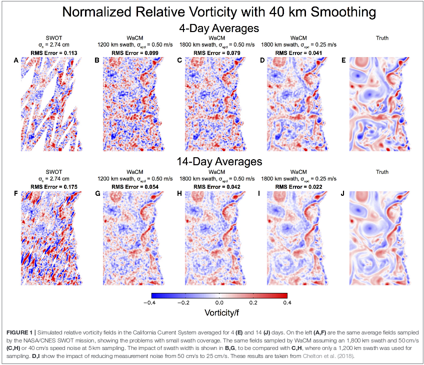
To fulfill these requirements, the satellite employs a Ka-band (vertically polarized) Doppler scatterometer with ~5 m by 0.3 m rotating pencil-beam antenna. The scatterometer pulse repetition frequency that varies with the antenna azimuth angle. The sensor measures wind and currents at the same time over a large swath (~1800 km) at a high spatial resolution (<5 km) with continuous spatial coverage. Figure 1 shows the effects of the swath and measurement noise have on the RMS error and resolution, and clearly shows that a wider swath and a lower measurement noise produces the most accurate image. Factors included in designing the WACM mission include:

A paper describing the WACM mission in more detail can be found here Citation: Rodríguez E, Bourassa M, Chelton D, Farrar JT, Long D, Perkovic-Martin D and Samelson R (2019) The Winds and Currents Mission Concept. Front. Mar. Sci. 6:438. doi: 10.3389/fmars.2019.00438 |