1978 & 1992-Present (Brigham Young University)
Jarom Ballantyne and David G. Long
7 June 2005
(Iceberg Tracks from 1978 & 1992-2005)
Updated by Ben Lambert for 2004-Present
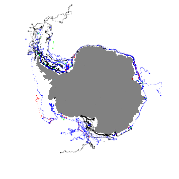
Using five different satellite scatterometer instruments, we have produced an iceberg tracking database. The BYU database includes icebergs identified in enhanced resolution scatterometer backscatter images during July-Sept. 1978 (from Seasat) and icebergs from 1992 to the present (ERS-1/2, NSCAT, and QSCAT). Images were obtained from the Scatterometer Climate Record Pathfinder (SCP) project.
Data sets from five different spaceborne scatterometer and radiometer instruments are used in the study. For each data set resolution enhancement is performed by BYU's Scatterometer Image reconstruction (SIR) and/or SIR Filtering (SIRF) algorithms. The scatterometer instruments used in this study are the Seasat-A Satellite Scatterometer (SASS), the European Space Agency's Remote Sensing Satellite 1(2) (ERS-1/-2), the NASA Scatterometer (NSCAT), and the QuikSCAT/SeaWinds scatterometer (QSCAT). The Seasat-A scatterometer (SASS) was a dual-polarization Ku-band (14.6 GHz) scatterometer that operated from July to Sept. 1978. Using the SIRF algorithm, Antarctic images are generated every 12 & 48 days (a longer time is required for SASS compared to other instruments due to the sampling characteristics of the nominally 50 km backscatter measurements). The ERS-1/2 spacecraft carried a C-band (5.3 GHz) active microwave instrument (AMI). The scatterometer mode provides nominally 50 km resolution data. Using SIR, Antarctic images are produced every 6 days. The ERS-1/2 scatterometers operated from Jan. 1992 to Jan. 2001. The NSCAT scatterometer is a Ku-band Doppler radar similar to SASS, but with dual-side measurement capability and a dense 25 km resolution sampling. Using SIRF, Antarctic images were produced every 3 days. The NSCAT mission lasted from Sept. 1996 to June 1997. QuikSCAT was launched as a ``quick recovery'' mission to help fill the gap created by loss of NSCAT due a satellite failure. This advanced scatterometer allows daily images of Antarctica to be created. QuikSCAT has opperated from July 1999 to the present.
The initial position for each iceberg is located based on either (1) a position reported by the National Ice Center (NIC)'s web page (URL: https://www.natice.noaa.gov/) or (2) by the sighting of a moving iceberg in a time series of scatterometer images. From an initial start point, the iceberg is tracked in the scatterometer image time series. Gaps in the position track result from missing scatterometer data and from the occasional loss of contrast between the iceberg and surrounding area during summer months. For each image a lat/lon position is reported for each iceberg.
Iceberg positions are reported in a separate ASCII text file for each iceberg. The file name is the same as that of the iceberg. For example the file "b10a.qscat" contains the position track information for B10A. A few lines from the b10a.qscat file are shown below:
lat: -73.1882 lon: -35.028 x: 1460 y: 2608 file: qush-Ant-a-20010180044-20010182252.ave
lat: -73.2415 lon: -34.984 x: 1462 y: 2606 file: qush-Ant-a-20010190011-20010192339.ave
lat: -73.2415 lon: -34.984 x: 1462 y: 2606 file: qush-Ant-a-20010200125-20010202333.ave
lat: -73.2780 lon: -35.095 x: 1462 y: 2604 file: qush-Ant-a-20010210053-20010212301.ave
Note that latitude and longitude are specified in decimal degrees with positive North and East, respectively. The next two numbers are the x and y BYU SIR-file format pixel coordinates within the scatterometer image where the iceberg position was determined. The last section contains the name of the scatterometer image file used to track the selected position. Two sources of scatterometer data files were used. Long QSCAT file names (such as in the B10A example above) are from the Near-Real-Time (NRT) processing stream. NRT images are somewhat lower grade the the science product images ordinarily used and available from the SCP web site. Science product images have shorter names, e.g. qush-a-Ant01-018-018.ave.
The iceberg database can be obtained via the links shown below. If desired, data can be imported into Microsoft Excel or other spreadsheet programs as "space delimited data".
DATABASE FILES
Entire database in a gzipped tar file from the SCP web site: database.tar.gz
Individual iceberg tracking files are available for each sensor through the web links below.
|
|
|
|
|
|
|
|
|
|
|
|
|
|
|
|
|
|
A report further describing this multidecadal database of Antarctic icebergs observed with scatterometer data is available in pdf format from the SCP web site at IcebergReport.
Dr. David G. Long
long@ee.byu.edu
Director, BYU Center for Remote Sensing https://www.cers.byu.edu/
Professor, Electrical and Computer Eng. Dept. https://www.ee.byu.edu/
Brigham Young University
https://www.byu.edu/
459 Clyde Building
voice: 801-422-4383
Provo, Utah 84602
fax: 801-422-0201
Microwave Earth Remote Sensing (MERS) Lab: https://www.mers.byu.edu/
Scatterometer Climate Record Pathfinder: https://www.scp.byu.edu/